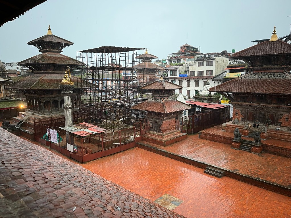
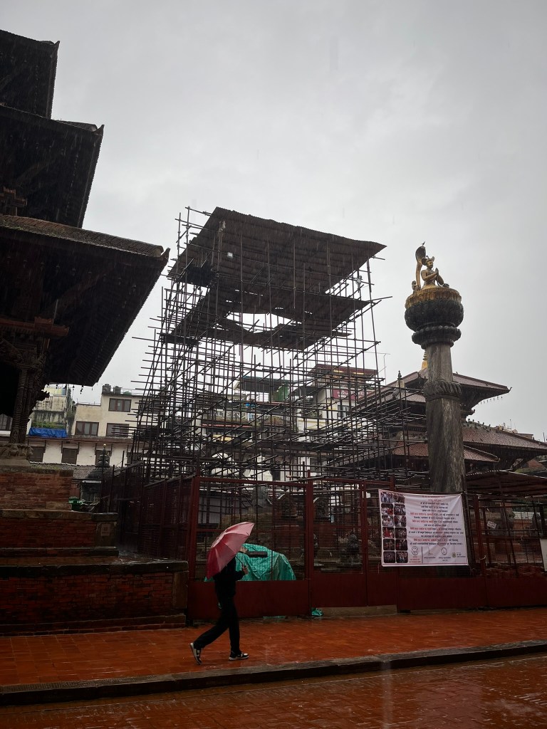
There are still many reminders in Kathmandu, ten years on, of the catastrophic earthquake that hit Nepal in 2015. In all three Durbar Squares of Kathmandu Valley, repair and reconstruction work continues on the temples and stupas that collapsed on that day (although it is also surprising just how much survived undamaged). And within residential areas there are still collapsed structures, abandoned and waiting to be rebuilt. With little to no government funding, and most people not covered for earthquake under insurance policies, reconstruction for some families will be impossible. This is a clear reminder that whilst we may see the news and aftermath of a major earthquake reported for a couple of weeks, or maybe even a month or so. But it takes years and often decades for places to recover.
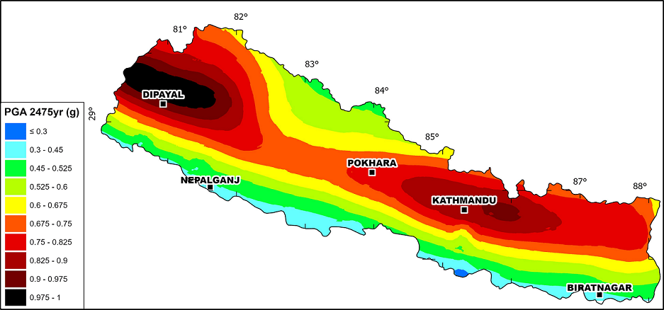
Earthquake risk in Nepal is extremely high. Nepal straddles the main Himalayan thrust where the Indian plate drives under the Eurasian plate. Large (Mw 7+) earthquakes are expected. Not all parts of Nepal are equally at risk though. The western and central Himalayas are considered higher hazard areas. The south lowland areas are lower in seismic hazard in comparison, though they can still be affected by strong shaking. Kathmandu Valley is especially at risk because of the soft sediment that lies in the basin, amplifying any shaking that is experienced.
The 2015 Gorkha earthquake occurred in April 2015 with the main shock measuring Mw 7.8. A major aftershock of Mw 7.3 was experienced a month later. Around 9,000 people died and over 22,000 were injured across Nepal. Around 600,000 houses were fully destroyed and around 300,000 partially damaged. There were also secondary disasters such as an ice and rock avalanche in the Langtang Valley that killed around 350 people and wiped out the affected village.
The heaviest destruction from the earthquake actually happened away from Kathmandu Valley in the hill districts north and east of the valley. The houses in these areas were built of dry stone and mud mortar without reinforcement that meant they were significantly vulnerable to earthquakes. And the steep terrain lead to many slope failures and landslides. These communities were hard to reach in rescue attempts in the aftermath, compounding the loss. Kathmandu Valley experienced lower rates of building collapse than the mountain districts because of the wider spread use of reinforced concrete frames, particularly for commercial properties. However, there was a huge amount of damage to historic monuments, older brick houses and non-engineered mid-rise buildings. This is because the soft sediments of the valley (remember the valley used to hold a lake!) amplified the shaking.
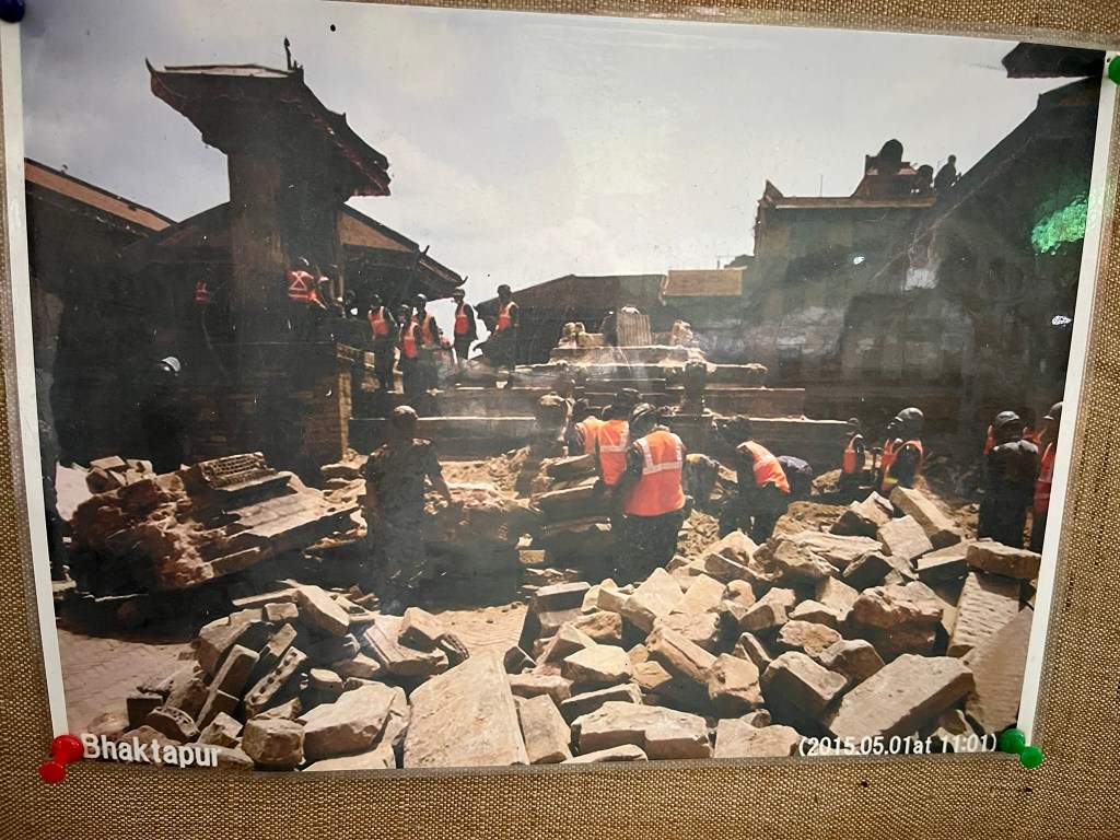
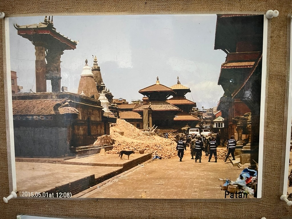
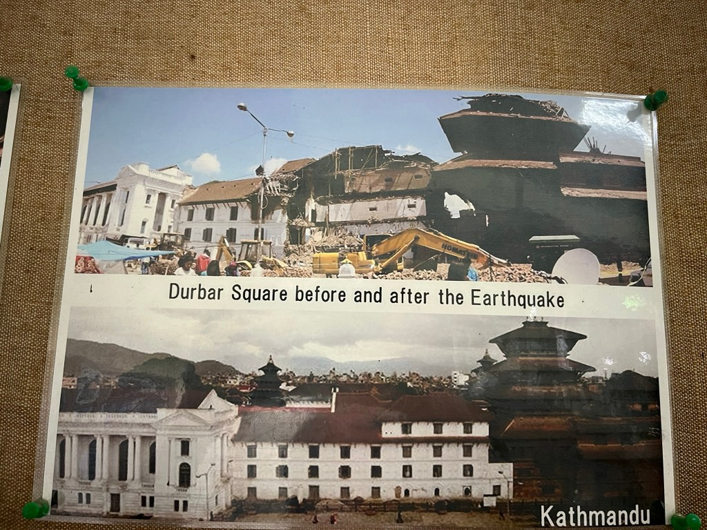
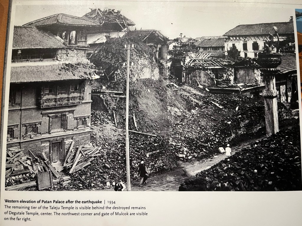
The iconic images of collapsed temples and stupas were broadcast across international news channels so I was curious when I visited each of the Durbar Squares to understand the true scale of what was destroyed and how the reconstruction effort was going. In total around 700 historic buildings in the country were damaged and 130 collapsed. Talking to my guide, although many temples collapsed or were severely damaged, when you compare it to the number that survived, it is a relatively small number. Many of the monuments in the squares were severely damaged in an earthquake that hit the valley in 1934 and had been reconstructed at that time to withstand future earthquakes. That earlier reconstruction effort is what saved Kathmandu Valley’s irreplaceable cultural heritage.
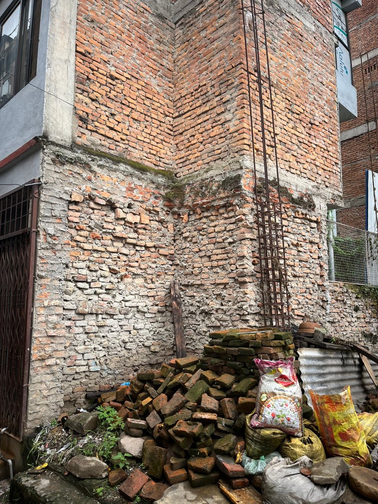
It was observed that the temples and pagodas that were constructed in a traditional style with brick and timber fared much better in the earthquake. The timber frames provided flexibility in the shaking. Buildings constructed of unreinforced stone and brick walls did not fare so well. Many of the buildings in Kathmandu have exposed brick walls, so you can easily see that the quality of construction is low, with very thin layers of cement between bricks and sometimes even gaps without any cement at all. The height and width of brick walls built with little reinforcement would make it easy for the whole wall to collapse in one slab.
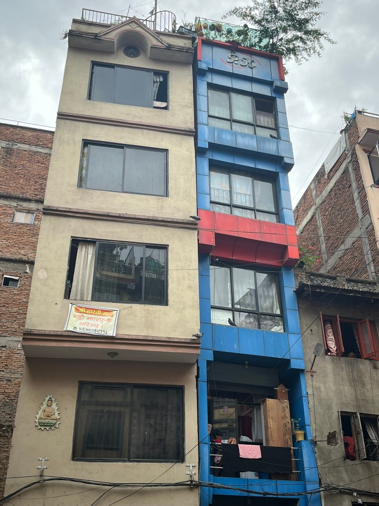
The buildings in Kathmandu tend to be tall and narrow. This is partially due to land scarcity and a growing urban population. Families who have a plot of land tend to build vertically to maximise space. As concrete-frame construction became available, families have replaced traditional brick and timber Newar houses that could go to a max of 2 stories with taller buildings. Only recently were building codes updated to limit heights, and 5-7 story buildings proliferated across the valley.
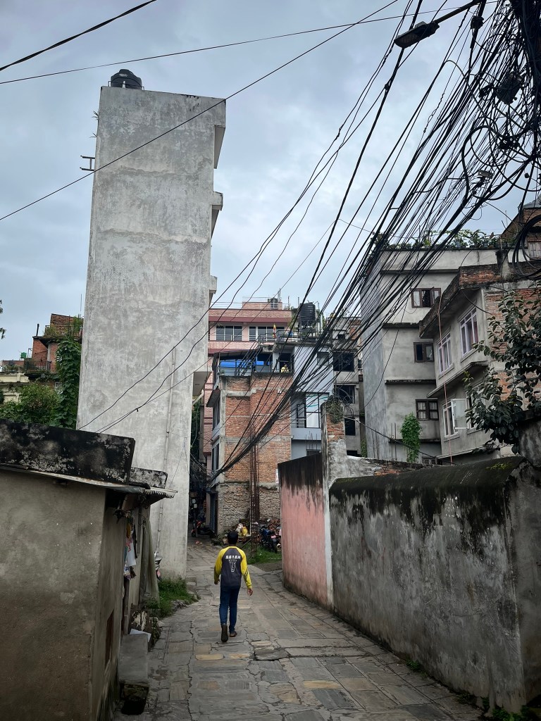
What has exacerbated this is that historically, property is divided equally among heirs and this means over generations the plots become narrower and shorter. This has resulted in architects being forced to design deep, stacked homes that sit tightly side-by-side with each other. Many residential buildings also have a soft-storey on the ground floor. This design of tall, thin properties with open ground floors that dominates that city’s skyline increases earthquake vulnerability. And proved disastrous in 2015.
During an earthquake, buildings like this which are tall relative to their base width sway much more and experience much stronger lateral (side-to-side) forces. Once the sway exceeds what the frame and brick infill can resist, columns crack or buckle. The masonry infill on upper floors of the building provides extra rigidity. But when shaking starts, the less rigid, open ground floor can’t carry the load of the heavier and stiffer upper floors resulting in the building ‘pancaking’ from the ground floor upwards. This pattern of collapse was commonly seen in 2015.
It is quite common in Nepal, for buildings to be extended upward over time without structural redesign. Each floor added, increases weight and shifts the building’s center of gravity upward, thus magnifying the amount of sway experienced during shaking. The foundations and columns have not been designed for these extra stories and become overstressed. In addition, even if a building has been constructed with a reinforced concrete frame, which in theory should reduce its vulnerability to severe swaying in an earthquake, the concrete mix is often a low quality, there are insufficient ties around the columns and there is inconsistent rebar splicing between floors. This makes the reinforced concrete brittle and unable to flex and dissipate energy like it is supposed.
In most cases in the valley, at least from my personal observation, adjacent buildings are touching or at best separated by just a few centimeters. In an earthquake, buildings will sway at different frequencies, depending on their height and how rigid they are. This means that adjacent buildings tend to collide and pound each other. This results in severe damage to the structure integrity of the building, even if the building does not collapse. I saw a great example of this on my first day exploring Kathmandu, where 2 adjacent buildings were now tilted away from each other and badly damaged, as a result of this pounding phenomenon.
In December 2015, the government established the National Reconstruction Authority to coordinate rebuilding. Its goals were to rebuild homes and infrastructure using earthquake resistant designs, to restore cultural heritage and religious monuments, to revive livelihoods and local economies, and strengthen resilience for future disasters.
Over 800,000 households were eligible for rebuilding grants and each household could receive up to 2,500 USD provided they followed approved earthquake-resistant designs. Talking to a couple of locals though, it is clear that for those whose entire homes collapsed…this amount was not enough to rebuild without additional sources of funds. They also confirmed it is not common for Nepalese to take out earthquake insurance. However, google tells me that 90-95% of private homes were rebuilt, which is pretty impressive.
Training programs were established to teach local masons safer construction techniques when using reinforced stone, brick or concrete frames. In the historic districts, salvaged materials were collected and used as much as possible in the reconstruction effort. And Newar woodcarvers and stonemasons were trained to preserve the authenticity of the monuments that had to be rebuilt. This is probably where it was easiest to see as a tourist how much care and attention has gone into the reconstruction effort. Bar a handful of temples that are still being worked on, the major sights of Kathmandu are open for business and if you weren’t aware there had been a major earthquake 10 years ago, you may not realise at all.
Some of the challenges experienced during reconstruction were bureaucratic processes that slowed down getting the housing grants out for people to start rebuilding their homes. For heritage properties there was a lot of debate about whether to use traditional or modern methods when rebuilding ancient monuments. In the end it seems like there has been a mixture, with some buildings rebuilt using the traditional (and flexible) brick and timber style, whereas others (more so in the residential area) have just maintained traditional facades but are modernized behind the scenes. This allows the city to maintain its cultural identity whilst also ensuring earthquake safety. A good blend of authenticity and resilience. Thousands of local masons were trained in how to construct earthquake-safe houses, in a ‘build back better’ program, which allows them to continue their livelihood but in a way that also means the new houses built are less likely to collapse in a future earthquake.
There has been a philosophical shift in disaster management within Nepal since 2015 from a reactive approach (responding after a disaster hits) to proactive preparedness and risk reduction strategies. A National Disaster Risk Reduction and Management Authority was established in 2019, which provides a legal framework for disaster governance. And co-ordinates with provincial and local governments to create disaster preparedness plans, early warning systems and response protocols. Nepal’s 2030 strategy aims for a ‘resilience Nepal’, where disaster risk reduction plans are integrated into all development plans, insurance coverage and social protection for post-disaster recovery are significantly expanded and nature-based solutions like reforestation and slope stabilization are encouraged to prevent landslides. The government also aims to increase cross-border cooperation with India and China in sharing hydrological data that will help flood management.
There has also been a shift towards a decentralized model, where local governments are directly responsible for disaster management and must have a plan that maps local hazards, identifies evacuation sites and outlines response procedures. Community disaster management committees have been established across the country, to organise search and rescue teams, identify vulnerable households and lead first-aid training. There is now an Earthquake Safety Day held annually and regular earthquake drills are run in schools. New schools are built to a new standard that ensures they are disaster resilient, energy efficient and multipurpose (so that they can serve as emergency shelters if needed).
The National Seismological Center continuously monitors seismic activity across Nepal and the government is in the process of developed an early warning system with support from Japan and the US. Pilot projects in Kathmandu Valley and Pokhara can now send alerts seconds before a tremor arrives, potentially allowing people to stop and take cover.
Beyond earthquakes, the Department of Hydrology and Meteorology has expanded its real-time rainfall and river monitoring network with hundreds of automated gauges, and there are now text and radio alert systems warning nearby communities of impending floods during the monsoon. International organisations like NASA help Nepal monitor its glacial lakes using satellite imagery to help predict glacial lake outburst events.
This preparedness is something I witnessed during the 3 days of extremely heavy rain that Kathmandu Valley has just experienced. Alerts were put out and the roads in and out of the valley were closed in advance, to avoid situations of people being caught in landslides or rapidly rising flood waters. Those living near or on flood plains in the city were proactively evacuated. And 2-day national holiday was announced so that everyone could stay safely at home and not travel if necessary. I also saw some trekking guidance that was sent out across the country, advising local communities to assist any trekkers caught in heavy rain and for the trekking companies themselves to take the appropriate steps to ensure the safety of their customers. Its clear that a huge effort is being made to avoid another disaster like 2015 repeating itself.

Leave a comment