Asia
-
The Longji Rice Terraces
The Longji Rice Terraces sit high above the villages of Longsheng County, about 100km northwest of Guilin. They have been cultivated for over 600 years, beginning in the Yuan dynasty and continued to develop through the Ming and Qing periods. The terraces follow the mountain contours up to altitudes of 1100m. My visit was timed…
-
Impression Lui Sanjie, Yangshuo
The Impression Liu Sanjie show in Yangshuo is one of the most spectacular outdoor performances in China. With over 600 local performers and taking place on a section of the Li River with 12 karst limestone peaks forming the backdrop, it is visually stunning. And a must-see when visiting Yangshuo. The show debuted in 2004…
-
The First and Second Sino-Japanese Wars
After a long 7+ hour train ride from Zhangjiajie to Guilin and a delay in getting picked up by the guide, who some how went to the wrong train station to pick me up, we jumped straight into sightseeing in Guilin City. Something that has come up quite a few times on this trip has…
-
Bamboo Rafting in Yangshuo
After arriving in Yangshuo via a cruise down the Li River, I had the rest of today and tomorrow morning to experience the best this small town, south of Guilin, has to offer. The selection of activities to pick from was extensive and I knew I wouldn’t be able to do everything. So I opted…
-
A River Cruise from Guilin to Yangshuo
The 4-hour cruise from Guilin to Yangshuo along the Li River is considered one of China’s top scenic experiences and the highlight of visiting the Guilin region. The karst limestone landscape is iconic – it is frequently seen in Chinese art and even appears on the country’s 20 RMB banknote. The starting point for most…
-
The Cave and the Elephant of Guilin
I arrived in Guilin mid-afternoon after a 7-hour train ride from Zhangjiajie and headed straight into the small city to start sightseeing. Guilin lies in the northeastern part of Guanxi Zhuang Autonomous Province in southern China and is famous for its dramatic karst limestone hills, lakes, caves and rivers. The city’s name translates to mean…
-
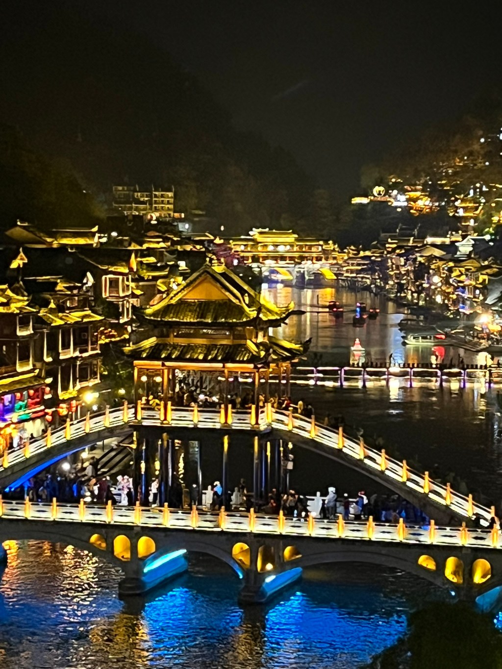
FengHuang Ancient Town
A local legend says that two phoenixes’ flew over and were so taken with the beauty of this ancient town that they lingered, giving it the name FengHuang or Phoenix. This ancient town is located within the Xiangxi Tujia and Miao Autonomous Prefecture of Hunan Province. The Tuojiang River runs through the town, defining its…
-
Furong – An Ancient Waterfall Town
Furong ancient town is one of Hunan Province’s most unique towns, built along the steep cliffs above the You River and with a waterfall cascading right through the middle of town. Furong is especially special at night, when the entire riverside is lit by glowing lanterns, and the waterfall is illuminated. Furong Zhen was originally…
-
A Cloudy Day on Tianmen Mountain
Not every day of a year-long travelling adventure can be perfect. And this was just one of those times where I had to accept that the weather was not good and I would have to suck it up and enjoy what I could. I had hoped that after a pretty cloudy day in Zhangjiajie National…
-
A Cloudy Day in Zhangjiajie National Forest Park
Zhangjiajie National Forest Park is located in northwestern Hunan Province, and is one of China’s most spectacular landscapes. It is a dream-like scenic area with sandstone pillars that reach into the clouds, mist and thick forest. And it is the inspiration for the ‘Hallelujah mountains’ that feature as the stunning background of the Avatar movie.…
-
Zhangjiajie Grand Canyon
Zhangjiajie Grand Canyon lies about 40km east of Zhangjiajie City. It is a lush, deep gorge carved by the Lishui river and its tributaries. The canyon is a subtropical forested valley with steep quartz sandstone cliffs, waterfalls, caves and clear streams. It formed over hundreds of millions of years through a combination of tectonic uplift,…
-
The Climb to Tiger’s Nest Monastery
Tiger’s Nest Monastery is Bhutan’s most famous landmark, perched on a sheer cliff 900m above Paro Valley. It is the main reason many tourists choose to visit Bhutan and is the iconic image used in pretty much all the country’s advertising. We left the hotel before dawn, with the aim to start making our way…
-
Climate Change in Bhutan
Bhutan is one of the few countries in the world that is a net carbon sink, meaning that it absorbs more CO2 than it emits. This is largely thanks to its extensive forest cover of ~70% of the country. And nearly all of Bhutan’s electricity is generated by hydropower which is a low-carbon energy source.…
-
Earthquake Risk in Bhutan
Bhutan sits on the Main Himalayan Thrust (MHT) where the India and Eurasia plates collide (same as Nepal). This plate-boundary fault system is capable of very large earthquakes of Mw 8+. However the seismic hazard is not uniform across Bhutan. The southern part of Bhutan, nearer the Himalayan front has the highest earthquake hazard because…
-
The 13 Traditional Arts and Crafts of Bhutan
Bhutan recognises thirteen traditional arts and crafts, known collectively as Zorig Chusum. They form the foundation of Bhutanese material culture and aesthetic tradition, blending spiritual symbolism with practical purpose. We visited the Institute of Zorig Chusum in Thimphu where these arts and crafts are still taught and had the chance to walk around the classrooms…
-
The Dzongs of Bhutan
The word dzong means fortress in Bhutan’s national language, Dzongka. Most dzongs were founded in the 17th century during Bhutan’s unification under Ngawang Namgyal, who built or rebuilt many of them to consolidate power and defend against Tibetan invasions. Every district in Bhutan has at least one major dzong that houses both the secular administrative…
-
No TV Until 1999 – A Modernizing Bhutan
Bhutan is famously known for not introducing television until 1999, the last country in the world. In fact, tv and internet arrived all at once in 1999, after decades of waiting so that it could be introduced after building the cultural and institutional foundations first. Bhutan has modernized step-by-step. First roads, then schools, then electricity.…
-
Phobjikha Valley
Phobjikha Valley is absolutely stunning and worthwhile the 3+ hour drive from Punakha. It sits on the western edge of the Black Mountains, about 135km from Thimphu and is famed for being the winter home of the endangered black-necked crane. Unlike most of Bhutan’s valleys it is broad and u-shaped, carved by ancient glaciers rather…
-
The Flag of Bhutan
The flag of Bhutan symbolises the country’s deep Buddhist heritage, its monarchy and its connection between spiritual and secular power. The upper triangle is golden yellow and represents the power and secular authority of the King. The lower triangle is orange, symbolizing Buddhism, particularly Drukpa Kagyu and Nyingma traditions, which are dominant in Bhutan. At…
-
A Brief History of Bhutan
Bhutan’s pre-7th century history is not very well-documented and no written records survive. The area that would become Bhutan was a mosaic of isolated highland valleys inhabited by small communities practicing animist (Bon) and shamanic religions, and worshipped mountain, river and forest deities. These communities were part of the broader Tibeto-Burman cultural sphere that extended…
